
the MEDICANES project
EARTH OBSERVATIONS AS A CORNERSTONE TO THE UNDERSTANDING AND PREDICTION OF TROPICAL-LIKE CYCLONE RISK IN THE MEDITERRANEAN
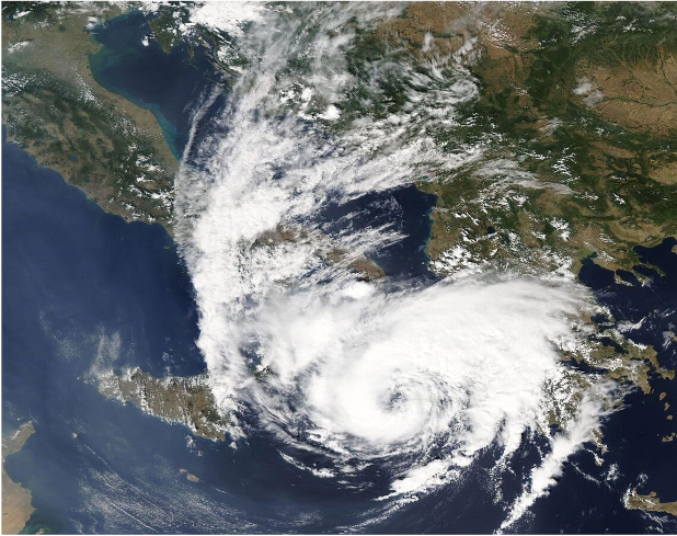
In the last decades, several Mediterranean cyclones have attained similar cloud structures, although with weaker intensities, to tropical cyclones. These systems compose a peculiar subcategory of Mediterranean cyclones, known in the scientific literature as medicanes (a portmanteau of the words Mediterranean hurricanes), or Mediterranean tropical-like cyclones. Despite their limited number to about 0-3 events per year, medicanes are directly related with high impact weather and thus have been constantly attracting the interest of the scientific community, but also of the general public.
They cause numerous fatalities and severe damages in several Mediterranean countries due to strong wind gusts, high sea waves and heavy rainfall. There is no doubt that medicanes constitute prominent environmental risks that affect more than 500 million people in one of the most densely populated regions of the world. In this project we will rely on Earth Observations (EO) to provide a comprehensive approach on the problem of increasing our understanding of medicanes, better forecasting their occurrence and quantifying the limitations of atmospheric modelling in reproducing relevant high-impact weather.
Objectives
Rely on advanced satellite EO systems and modelling capabilities to develop new concepts, methods and tools to:
★ Phase 2 — Project Extension (2026–2028)
Building on the significant achievements of Phase 1 — including the first open Medicane Atlas, a community-endorsed definition published in the Bulletin of the American Meteorological Society (Miglietta et al., 2025), and major advances in EO-based monitoring, diagnostics, and modelling — the MEDICANES project has entered a new phase in 2026, with a clear overarching goal: to transform EO-based medicane science into actionable information for civil protection, climate adaptation, disaster risk reduction, and impact-based forecasting. Phase 2 extends the EO value chain established in Phase 1 — from detection and diagnostics — towards hazard characterisation, exposure and vulnerability assessment, and quantitative impact indicators.

Two Complementary Research Pillars
Translating EO-based medicane diagnostics into quantitative, spatially explicit socioeconomic impact indicators. The workflow integrates Copernicus Emergency Management Service products, the open-source CLIMADA modelling platform, and the Social Vulnerability Index to produce multi-hazard footprints, exposure maps, and risk indicators for ten historical medicane events (1995–2023). A key output will be the Medicane Impact Viewer (MIV), an interactive geospatial platform for civil protection and climate adaptation use.
Going beyond the traditional EO + modelling dual approach to create a deep synergy: high-resolution Meso-NH simulations coupled with the RTTOV radiative transfer code emulate satellite observations directly, enabling rigorous model-observation comparison. Synthetic Digital Twins — generated with WRF by nudging intense Mediterranean cyclones toward medicane conditions — will expand the AI training database and support impact assessment under extreme scenarios.
Expected Outcomes
Strategic Collaborations
Phase 2 is conducted by an expanded consortium — CNR, CLS, UT, IFREMER, CEAM, GEO-K, HCMR, and INNUERE — and builds active synergies with the FutureMed COST Action, Horizon Europe ARTEMis, Copernicus Emergency Management Service, Copernicus Land Monitorinf Service, CIMSS-UW-Madison, ESA Φ-lab, and the ESA Earth System Science Hub (ESRIN).